NEWFOUNDLAND AND LABRADOR:
A ROAD TRIP TO REMEMBER
For many years I had been trying to plan a road trip to Newfoundland but had been unable to coordinate with anyone willing and able to make the journey with me.
My wife, being a dialysis patient, was unable to undertake such a trip because it would be impossible to arrange for her regular treatments while being regularly on the move.
Finally my youngest son was able to get the time to accompany me, as he had done twenty-four years earlier on a road trip to the west coast of Canada. In fact it was he who suggested we include Labrador City as part of our itinerary.
It was very late in the afternoon of July 5, 2010 when we finally got on the road from Peterborough, Ontario for what would be roughly a month long journey.
We had wanted to get well past Montreal on our first day but that was going to be a challenge, given the lateness of our departure.
The first leg of our journey was uneventful and we were making very good time but as we traversed through Montreal we encountered traffic backed up on the highway and had to detour through city streets.
As we passed the scene we could only partially see the tangled mess blocking the highway and were thankful we had not been in the wrong place at the wrong time.
It appeared this was a major accident involving at least three tractor-trailers and a small car, resulting is major damage and, we suspected, serious injury, if not worse, although we never did hear a report.
In order to put some distance behind us we continued well into the evening and then got a motel room for the night near Berthierville, Quebec.
The next morning we headed out along the north shore of the St. Lawrence River, through Quebec City.
We had visited this historic city on several occasions, including a visit during the famous winter carnival held there each February. The city has a rich history and is well worth a visit, either for the winter carnival or during the summer.
We made a short stop in St. Anne de Beaupre, located about 30 km east of Quebec City. Again we had made stops there on a couple of other trips.
The main attraction in St. Anne de Beaupre is the Basilica. This is a spectacular site and a huge tourist draw, attracting about a million visitors annually.
As you enter the building you notice that the walls are lined with crutches and braces. The Catholic Church credits the basilica with numerous miracles of healing.
It was in the afternoon when we crossed the Saguenay River by ferry from Baie-Sainte-Catherine to Tadoussac. There is no bridge crossing unless you go all the way up to Chicoutimi.
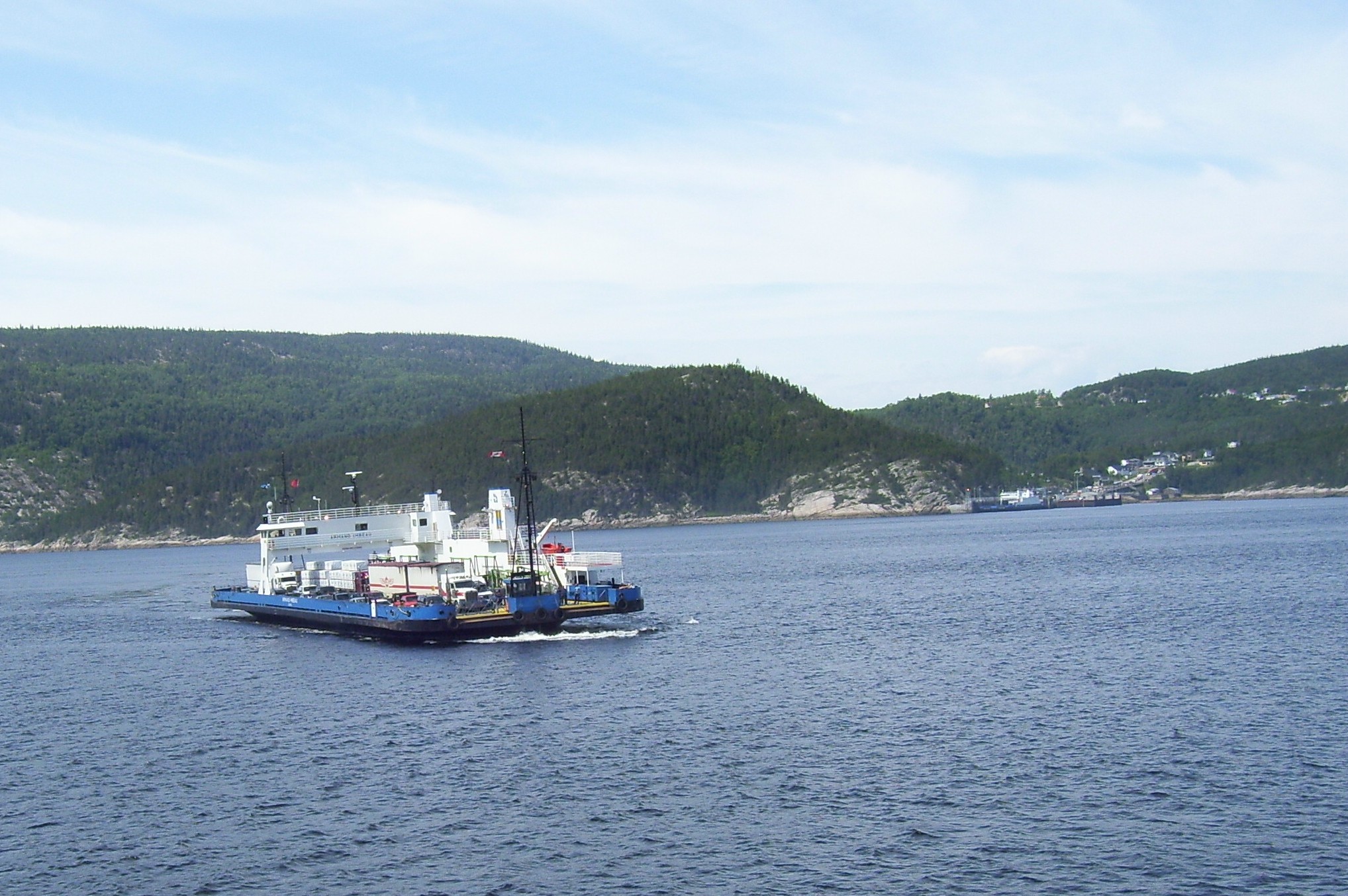 We now entered a part of the province that we had not visited before and the scenery in the eastern part of Quebec is breathtaking.
We made it to Baie Comeau late in the afternoon. There we stocked up on supplies, filled the tank with gas and headed north on highway 389.
Before long we approached the Manic 2 Power dam and just around a bend past the entrance to the dam site there was a campground, where we decided to stay for the night.
Early the next morning, after a hearty breakfast in a restaurant across from the campground, we headed out on what would prove to be an unforgettable part of our adventure.
We made it to the Daniel Johnston Dam, also known as the Manic 5 power dam, in time for the first tour of the day at 9:30.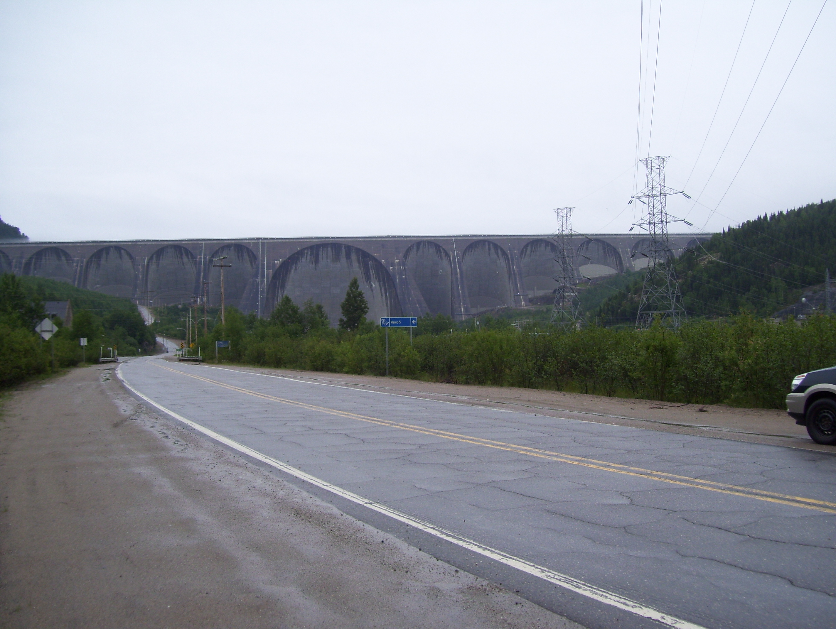
Located on the Manicouagan River, (the origin of the manic reference to the several dams built on the river). This is a massive structure about one mile (one and a half kilometers) wide and 702 feet (216 meters) high. It is the world’s largest multi-arch-and-buttress dam and it is stated in their literature that the entire Place Ville-Marie office tower in Montreal, a 46-story office tower, would fit inside the main arch.
This river had long supported a huge pulp and paper industry and drains more than 16,000 square miles (41,000 square kilometers) of a heavily forested region.
Construction began in September 1959 on the road from Baie-Comeau that would service the dam. Construction of the dam itself was completed in the spring of 1964. The entire project was completed in 1968.
The project took about seven years to complete and during construction employed over 3000 men. A town was built to accommodate them and their families, including an on site hospital.
The structures were later moved to a new location after completion of the power facility. The dam contains 2,200,000 cu. meters (2,900,000 cu. yards) of concrete.
A guided tour takes you inside the dam, as well as on top and lasts about two hours. Tours are in French but English tours are available for groups of 10 or more if booked in advance. Call 1-866-526-2642 for information and tour bookings.
There are two powerhouses. The first has a capacity of nearly 1600 megawatts of power and the second almost 1100 megawatts. The facility supplies power to much of Quebec and parts of the northeastern U.S.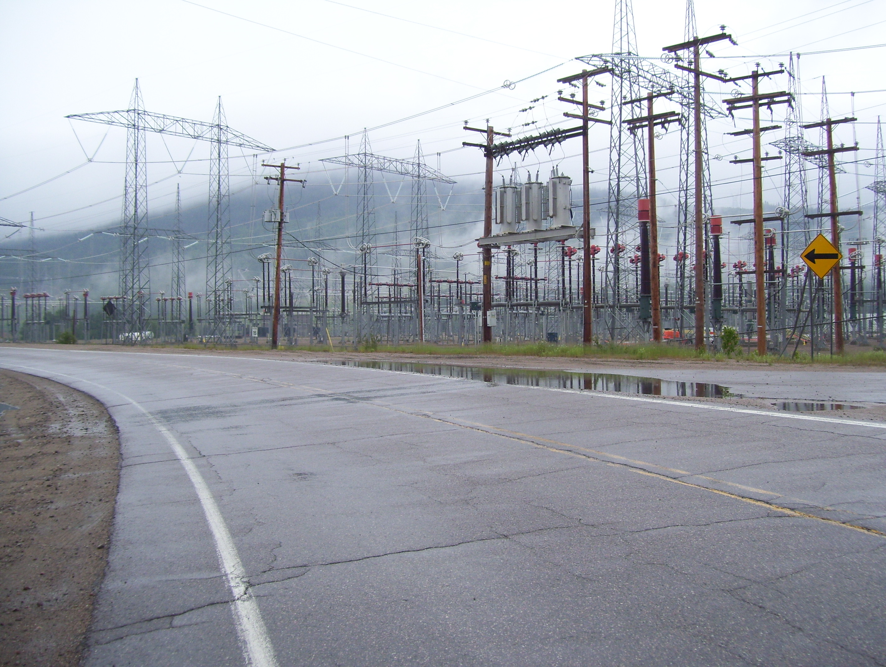
On our way to the dam we passed a transfer station that distributes the electric power from the facility. This is an enormous distribution center that literally emitted a loud humming sound as the millions of watts of power passed through it.
The dam is located at km. 216 along the highway and as we drove north we observed that the reservoir continued on beyond km. 288. In fact the provincial map would indicate that it reaches possibly as far as km 400.
Between km. 317 and 318 there is a gas station where it is wise to top up the tank, as it is the only one between Baie Comeau and Fermont, Quebec, just short of the Labrador border and it is over 600 km. through the bush from Baie-Comeau to Labrador City.
Between km. 393 and 394 is the southerly boundary of the former mining town site of Gagnon, which at its peak had a population of more than 4000, although at the time was only accessible by air.
 The town was dismantled in 1985, including most streets but curbs, sidewalks, sewer covers, a center median and street and driveway entrances are still in tact along the main street, which is now part of highway 389.
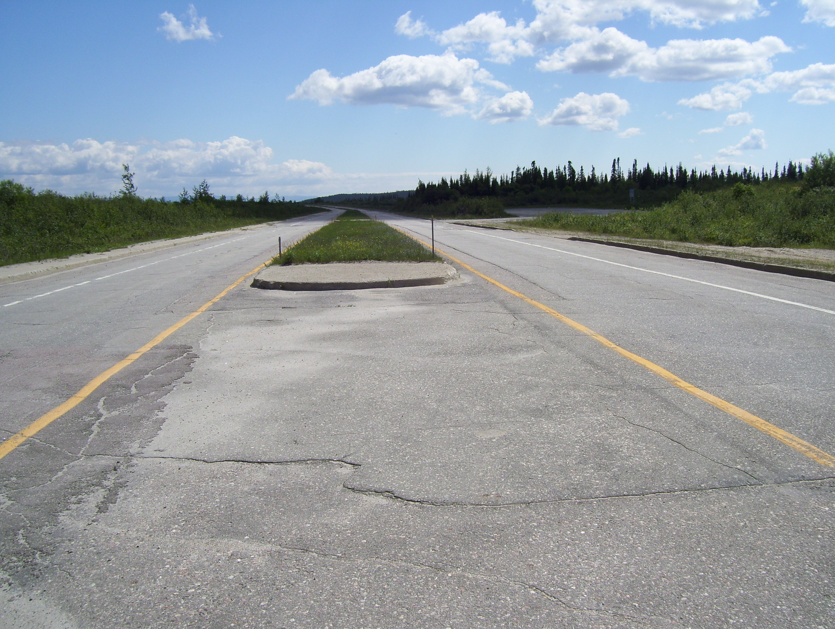
The road is gravel but quite straight from Manic 5, with paved sections from Gagnon north for approximately 90 to 100 km.
There is a gravel section from Fire Lake to just before Fermont, which is very winding and there is a lot of loose gravel. This is the worst and most dangerous section of the highway.
It is also important to note that it crosses a rail line on frequent occasions and that one must also be alert for the many heavy trucks that travel this highway. The logging industry is still very active in the area.
In the course of the trip along highway 389 we crossed the 50th, 51st and 52nd parallels. This puts you as far north as the southern part of James Bay.
At km. 516 we got our first view of Mont-Wright, which at this point is still about 45 km away and is being mined for iron ore, a project that began in the 1970’s after the depletion of the mine at Gagnon. This is a mega project that has over 1000 employees and extends over 24 square kilometers. It is estimated to have a capacity of one billion tonnes of crude ore. The road passes very close to the operation; in fact there is actually activity on both sides of the highway. The road improves at this point and continues on to the Labrador border.
We took a brief side trip into Fermont, which translated from the French literally means Iron Mountain.
The most notable feature of the town is a huge self-contained structure, which is made up of apartments, schools, restaurants, bars, a hotel, a swimming pool, a super market and other stores.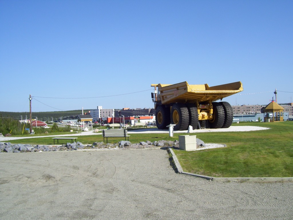
It is 4300 feet long and 160 feet high and serves as a windscreen for the rest of the town, allowing many of the residents to avoid going outside during harsh winter conditions, except to go to work at the mines.
In a park at the entrance to the town there is a huge dump truck on display that had been used in the area iron mines. This monster truck is capable of carrying a payload of 190 tonnes.
We would later find that the trucks now used in the mine in Labrador City are even larger. Those trucks, worth $3-million each, weigh over 385,000 kilograms and have a load capacity of 218 tonnes. They are over 44 feet long, 24 feet wide and 23 feet high with a 2,500-horsepower Cummins V16 diesel engine. We were told that each tire on these monsters costs about $50,000.
As we crossed the provincial border into Labrador we started looking for Duly Lake 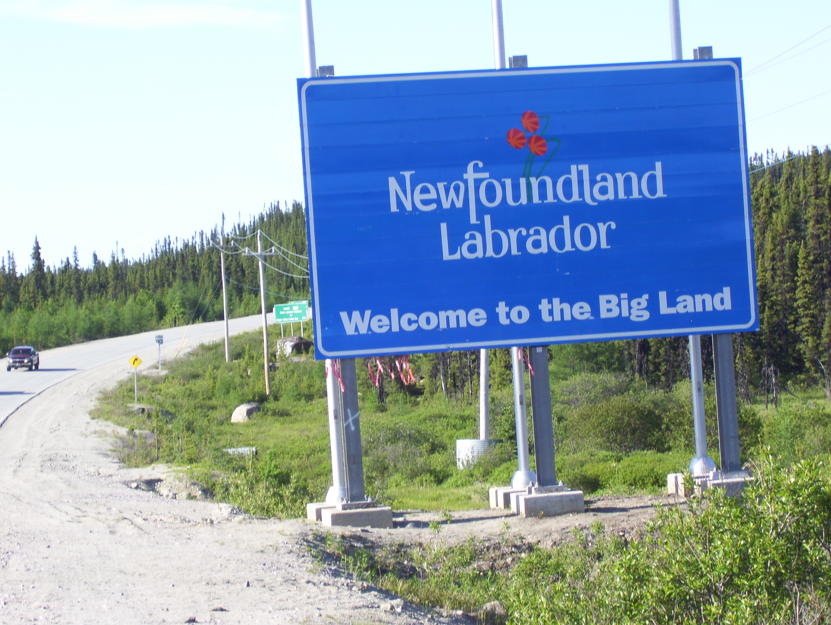 Campground, which we had read about in our guidebook. It is located a short distance to the south west of the city limits but we missed the turn and had to seek directions in town.
As it turns out there is no sign on the highway directing one to the campground, much to the chagrin of the owner. He explained that he is not allowed to place a sign along the highway. However, we were able to find it with the assistance we received from a convenience store employee.
We stayed there for two nights and were able to arrange for one of the tours of the Iron Ore Company of Canada mine. This is a massive facility where a former mountain is now a hole in the ground and other mountains are undergoing the same treatment.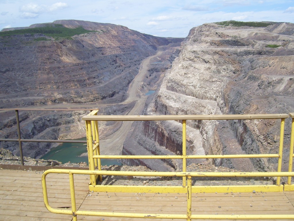
It is a 24-7 operation and we were told as many as seven trains per day leave the facility loaded with iron ore pellets and/or concentrate.
According to the company’s web site, each train can have up to 230 cars and haul up to 24,000 tonnes of product, which it says is loaded at a rate of one car or 100 tonnes per minute.
Since 1962 the mine has produced 1.3 billion tonnes of crude ore and has the capacity to continue for years to come.
They have nearly 2000 employees working at the mine site, the shipping facilities in Sept-Isle and offices in Montreal.
On July 9 we gassed up and headed out on the trans-Labrador highway for Churchill Falls, 245 km. to the northeast. Along this route, although we didn’t see a sign indicating that we had crossed the 53rd parallel, the map would indicate that in fact we did or at least came very close to doing so.
The highway is mostly gravel but was being paved at the time of our visit. About 50 km had been completed eastbound from Labrador City.
We had purchased fishing licenses in Labrador City and made a couple of brief stops to fish along the way but with no luck.
Arriving in Churchill Falls just around 1 p.m. we had lunch in a nice little restaurant, housed in the town’s shopping complex.
Arrangements to tour the power facility in this west central Labrador town had been made in advance; however, upon checking in with the town office we were informed that the elevator was broken down and would be out of commission over the weekend and it would be early the following week before we could take the tour.
This was unfortunate because this too is an impressive facility, being the largest underground powerhouse in the world.
The heart of the project is a 5,428,500 KW power station. The elevator descends approximately 1000 feet below the surface.
The potential for electrical generation was recognized as early as 1947 but it was nearly 20 years later before construction on the project and town site began and like the Manic 5 project in Quebec, employed over 3000 workers during the construction phase.
After many years of planning and five years of non-stop fieldwork, employing approximately 6300 workers over that time, the first two generating units began delivering power on December 6, 1971, almost six months ahead of schedule and under budget.
The powerhouse consists of eleven turbines generating the nearly 5.5 million kilowatts of electricity, most of which is distributed to the Hydro-Quebec grid.
There are spaces in town where we could have pitched a tent but we were warned that bears often wander into town at night.
Unable to take the tour we decided to move on to Happy Valley-Goose Bay (HVGB) but not before making a stop at the local landfill site, which the local children refer to as the Churchill Falls Zoo. There we saw several black bears rummaging through the garbage. We also encountered one large bear on the roadside.
Arriving in HVGB in the early evening we had no time to explore the area that evening and rented a campsite just north of town.
The next day we drove the short distance to North West River, which claims to be Central Labrador’s oldest community. There we visited the Interpretive Centre and the old Hudson Bay Company Store, now known as the Labrador Heritage Museum.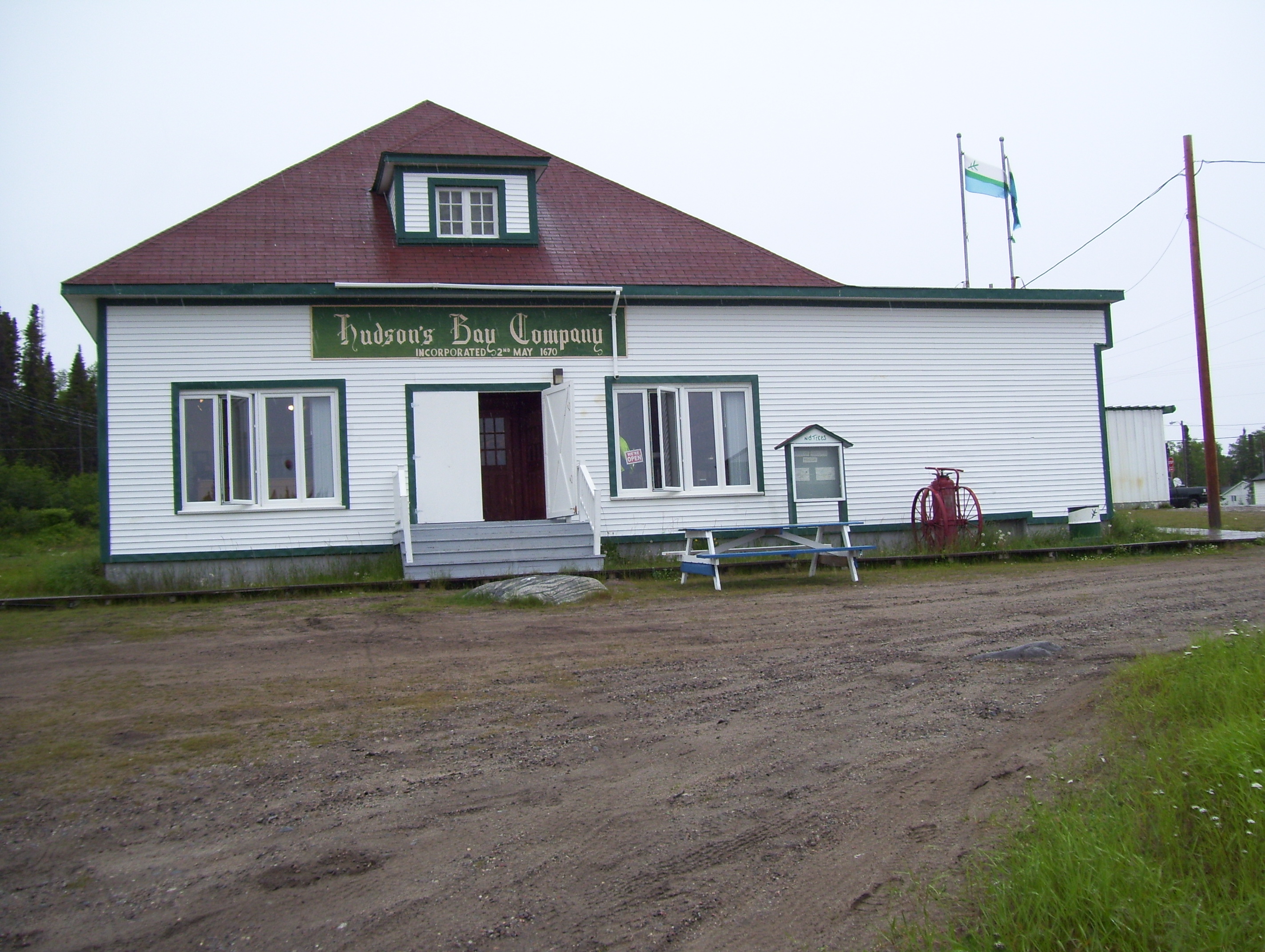
This small town has a rich history rooted in the fur trade dating back as early as 1743, see www.townofnwr.ca/home/5 for more details.
Back in HVGB we were fortunate to have the Mayor, Leo Abbass, give us a guided tour of the town and it was interesting to see the amount of construction taking place in the HVGB area. The cost of an average single-family dwelling is about $300,000.00, comparable to most Canadian towns and small cities.
According to the Mayor, who obviously has great pride in his community, Happy Valley-Goose Bay “has an abundance of recreational, cultural and social qualities that would be difficult to find anywhere else in a town our size.” The town web site, www.happyvalley-goosebay.com also has a similar statement posted.
Although the Canadian Forces Air Base is not as active as it once was, it still plays an important part in the town of approximately 7500.
The airport, which operates within the confines of the military base, is a major international airport and handles an average of 95,000 passengers a year.
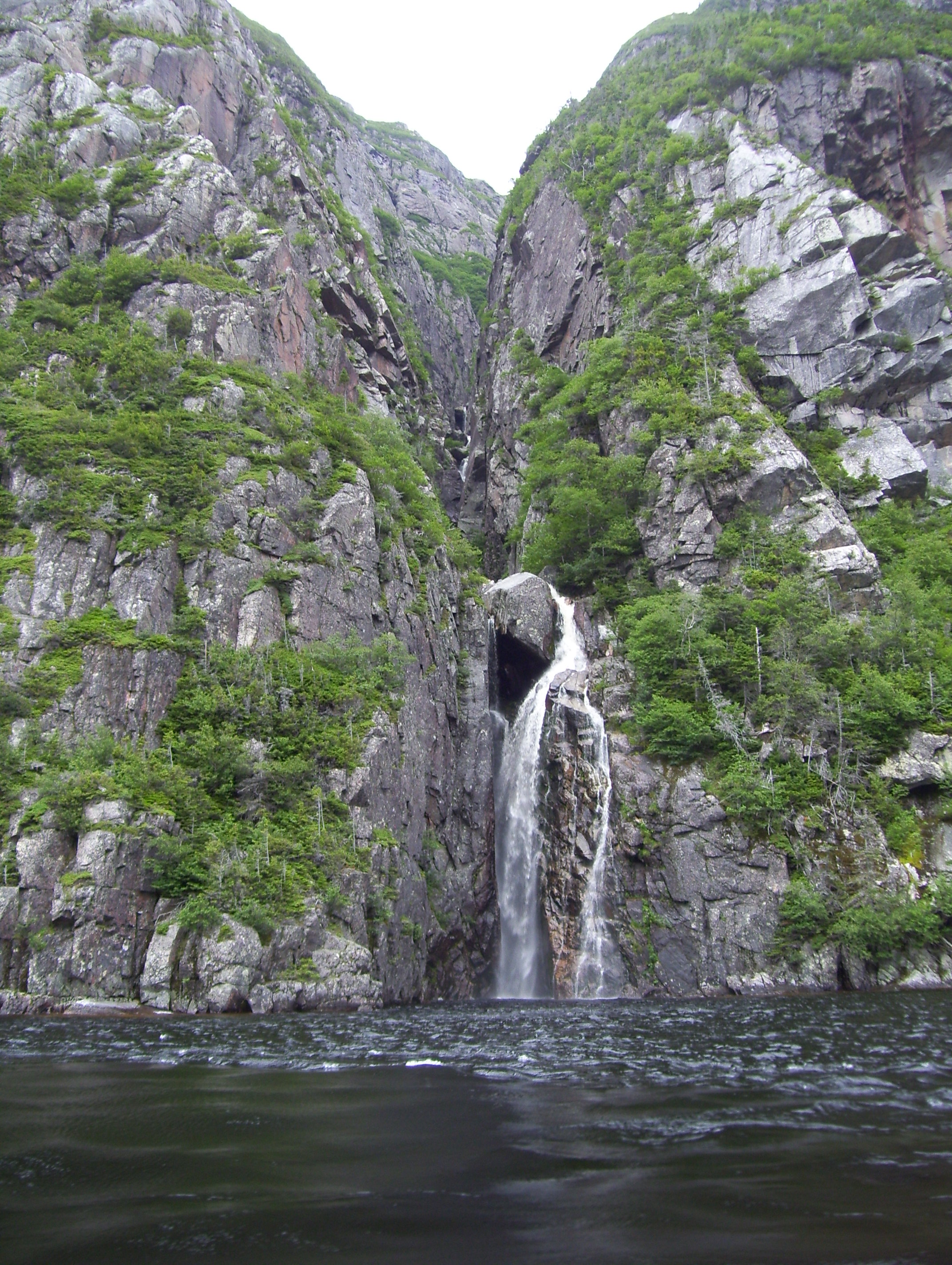
On the morning of July 11, before moving on, we drove out to a site along the highway and 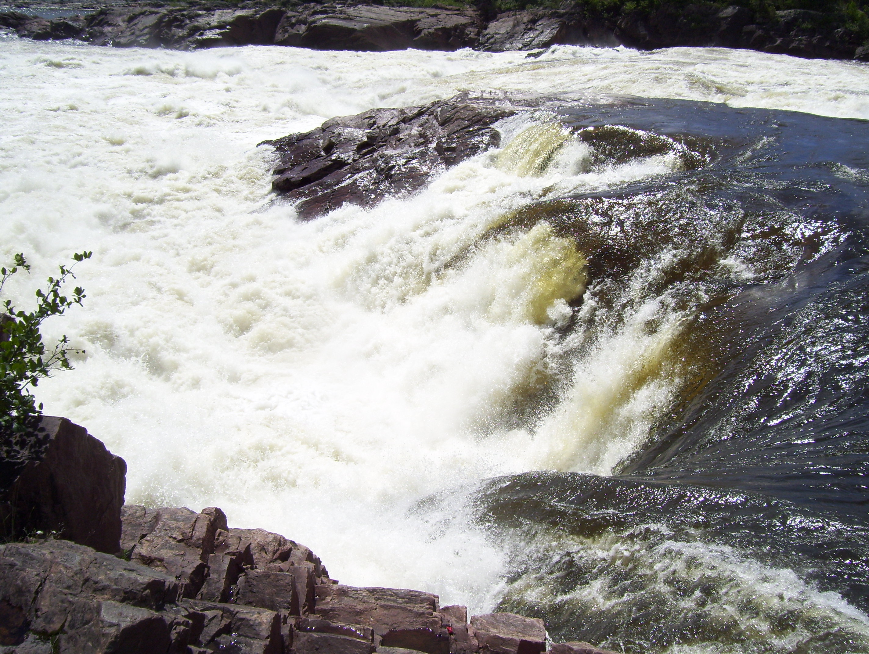 hiked to Muskrat Falls.
This appears to be more like a set of very impressive and dangerous rapids but has a drop of about 15 meters (nearly 50 feet) on the Churchill River and is one of two sites along the lower Churchill being considered for major power plants.
It is an unspoiled wilderness area and there have been cases of individuals being swept over the falls, with undesirable results.
The trail is easy to follow but not maintained to any particular standard and one must be careful, as there are damp and slippery sections.
Here, as we found in most areas of the province, the onus is on the individual to make responsible decisions. Rarely are there any guardrails or barriers to prevent people from approaching dangerous cliffs, etc. Common sense must be employed and people are expected to take responsibility for their own actions.
From here we headed through the new highway that was being constructed to link HVGB to the southeastern part of Labrador. Until now it was necessary to take an over-night ferry from HVGB to Cartwright.
The connection had been completed in December 2009 but major work was still underway. Although the highway was not yet officially open, it was possible to drive, however, there were a couple of areas where we had to travel about 5 km per hour over rocks.
Picking our way carefully over this long awaited link, we emerged onto the Coastal Highway that runs from Cartwright to the south shore at Blanc-Sablon and the ferry to the northern peninsula of Newfoundland.
Arriving in Port Hope-Simpson, where we camped for the night, we encountered the worst infestation of mosquitoes I have ever seen. This has to be the mosquito capital of the world. We ended up sitting in the car to eat our dinner but managed to keep most of the little pests out of our tent, although it was a real challenge pitching the tent.
On July 12 we took a side trip into the small town of St. Lewis in an area known as iceberg alley.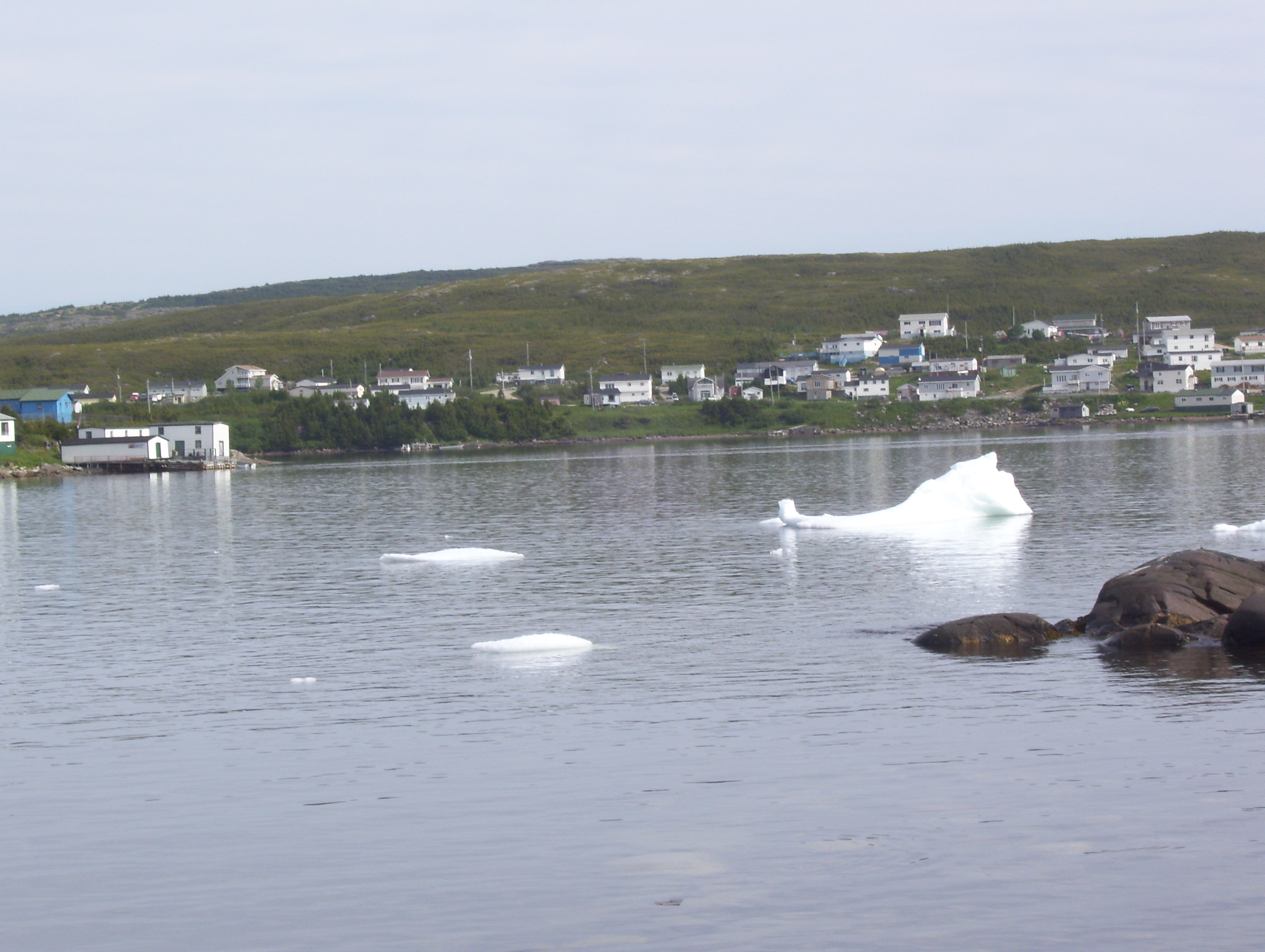
In 2010 there were not a lot of ice burgs present but we did see the remains of a few small ones in the harbor area and in the cove.
Driving up a narrow, rough and steep gravel road from the town, we made our way to a lookout at the top of the hill.
This area was settled originally by some very hardy souls but the winters proved too harsh and they later moved inland to the present town site.
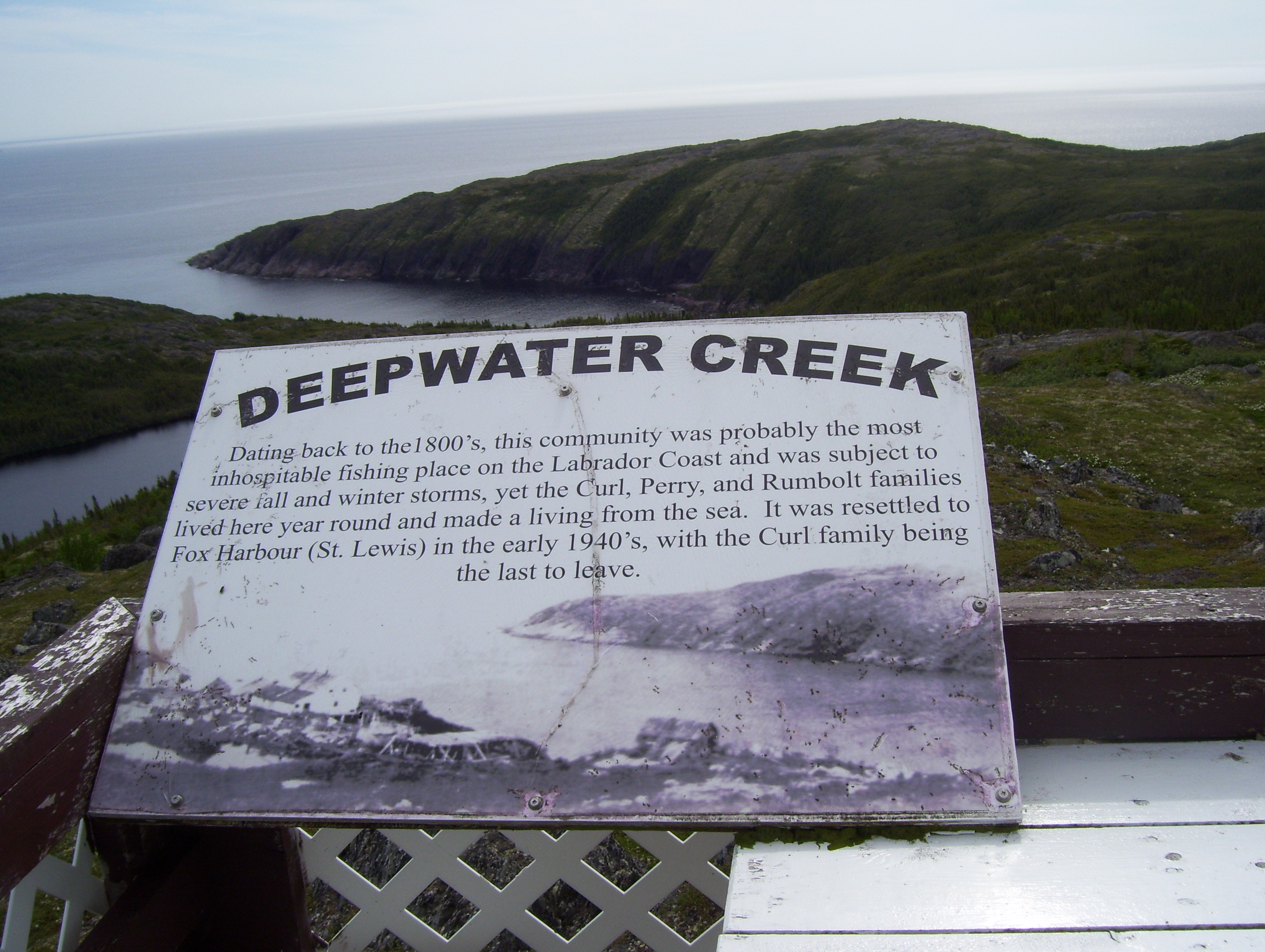
There is a boardwalk and trail that leads down the hill to the shore. This is the most easterly point on the North American mainland.
As we drove on to Red Bay it began to rain, which made it difficult to engage in any outdoor activities.
Red Bay is now a World Heritage Site. A Basque whaling boat, like those used in the 1500’s was discovered in the harbor of this small town of about 200, which was built inadvertently on the site of a former Basque whaling village.
We made a brief stop at the museum and then decided to carry on and see if we could catch the ferry to the northern peninsula of Newfoundland, a day in advance of our booking.
We were too early in the year to experience the annual bakeapple folk festival in L’Anse-au-Loup, which is held the second week of August. I’m sure it would have been an interesting experience had we been able to attend.
Bakeapples are a popular berry in the area and the name originates from the French baie qu’appelle. They are a small berry much like a raspberry or mulberry and grow on small plants somewhat like a strawberry plant. They are a light orange in color when ripe and are used in jams and various other preserves, as well as consumed in the natural state. We were able to purchase some jam made from these berries and found it quite appealing, not too sweet and easy to spread on toast.
Arriving at the ferry terminal after dinner we were in luck, as there was room on a sailing that was to leave in about a half hour. As it turned out the ferry had to wait for an ambulance and our sailing time was delayed for about a half hour.
This put us a bit late reaching St. Barbe on the northern peninsula, yet we decided to drive on to St. Anthony.
The rain continued and darkness fell, which is a dangerous combination with all the moose that are present along the roads.
Vehicle collisions with moose number around 700 annually in Newfoundland, some fatal, and the summer months have the highest percentage of collisions.
A cost estimate for vehicle damage alone is in excess of $1 million a year, not to mention the medical costs and lost time from work resulting from injuries sustained in these collisions.
Since these animals can weigh up to 700 kilograms (over 1500 lbs.) it is not surprising the damage a collision with one of them can cause.
We saw many of these creatures on the roadside, fortunately none of them so up close and personal as to cause any real concern.
Moose are not native to Newfoundland. A pair of them was introduced to the island by the government in the early 1900’s. Officials lost track of that pair and a second pair was introduced. They have thrived and the population is now estimated to be between 120,000 and 150,000.
We were interested to learn that there are also no snakes or skunks in Newfoundland and I doubt that the government will introduce those species to the island.
It was late when we arrived in St. Anthony and the rain continued to fall, not the best weather for pitching a tent, so we attempted to find a motel, only to discover that there were no rooms available anywhere in town.
This is the area of the famous L’Anse Aux Meadows Viking settlement often advertised on TV and many tourists visit the town and surrounding area every year.
The Vikings were the first European settlers to set foot on Newfoundland soil more than 1000 years ago, or as they then called it, Vineland.
At one of the motels we encountered a desk clerk that said she knew someone who had a trailer that they sometimes rented out. She called the gentleman and we were able to arrange to meet him to view the trailer. Our expectations were not very high at this point but we really had no other choice.
When we arrived at the trailer we were pleasantly surprised. It turned out to be a new double wide, completely furnished home with a washer and dryer, stove, fridge, satellite TV, two bedrooms and all the comforts of home, all for a very reasonable price.
Taking advantage of this luxury we purchased groceries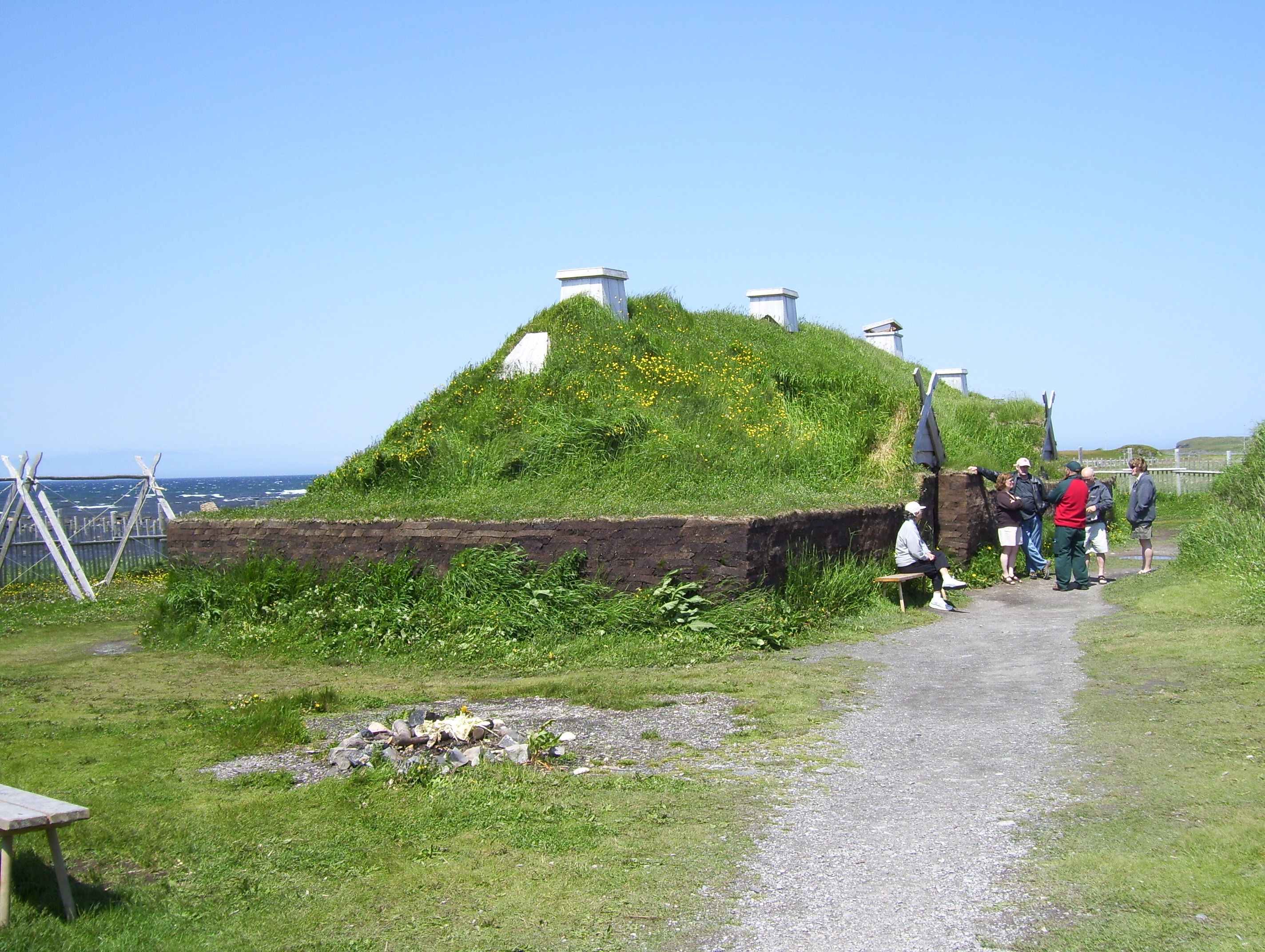 then cooked and froze meats for the next leg of our trip.
On July 13 we visited the Viking settlement site at Lance aux Meadows and took the tour. A new interpretive center was under construction but the area was still accessible.
This too is a rather harsh location and I’m sure those early settlers endured some very challenging times.
That evening we attended the Great Viking Feast in St. Anthony and this I would recommend to anyone visiting the area. It is a one of a kind experience.
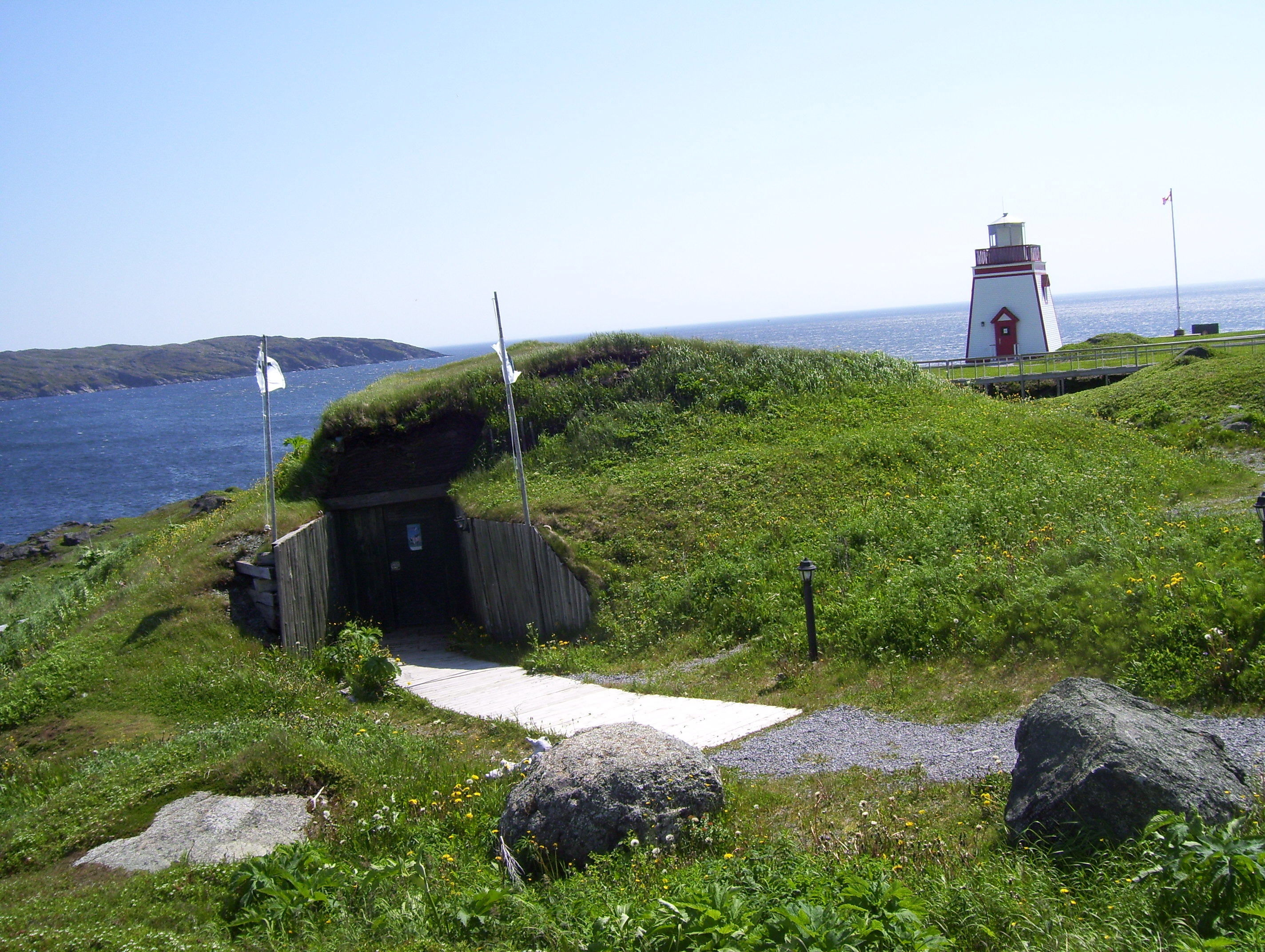 The feast is located in a building that is completely under an earthen mound. The menu consists of a number of interesting dishes and includes such things as cod tongue and moose stew. There is seating for about 100 patrons and advance booking is necessary to assure you will be accommodated.
After the dinner there was a mock trial where each table picked someone and charged him or her with some ridiculous offense. The accuser had to present their case against the defendant and the defendant then got to mount a defense.
The crowd voted them guilty or innocent by pounding on the table. If they were found innocent then the accuser was guilty of making a false accusation. Each guilty party was given an equally ridiculous penalty, usually to be served the next day. The entire evening was hilarious and immensely enjoyable.
At the end of the evening, as we were leaving, we were presented with certificates designating us as honorary Vikings. This was certainly one of the highlights of our entire trip.
Just across the road from the site of the Viking feast is Daredevil Trail and we made the climb up 476 steps to the top of a cliff overlooking the town and surrounding area. There is a panoramic view of the town and ocean.
Also in St. Anthony we visited a display, which, among other things, referenced the size of icebergs.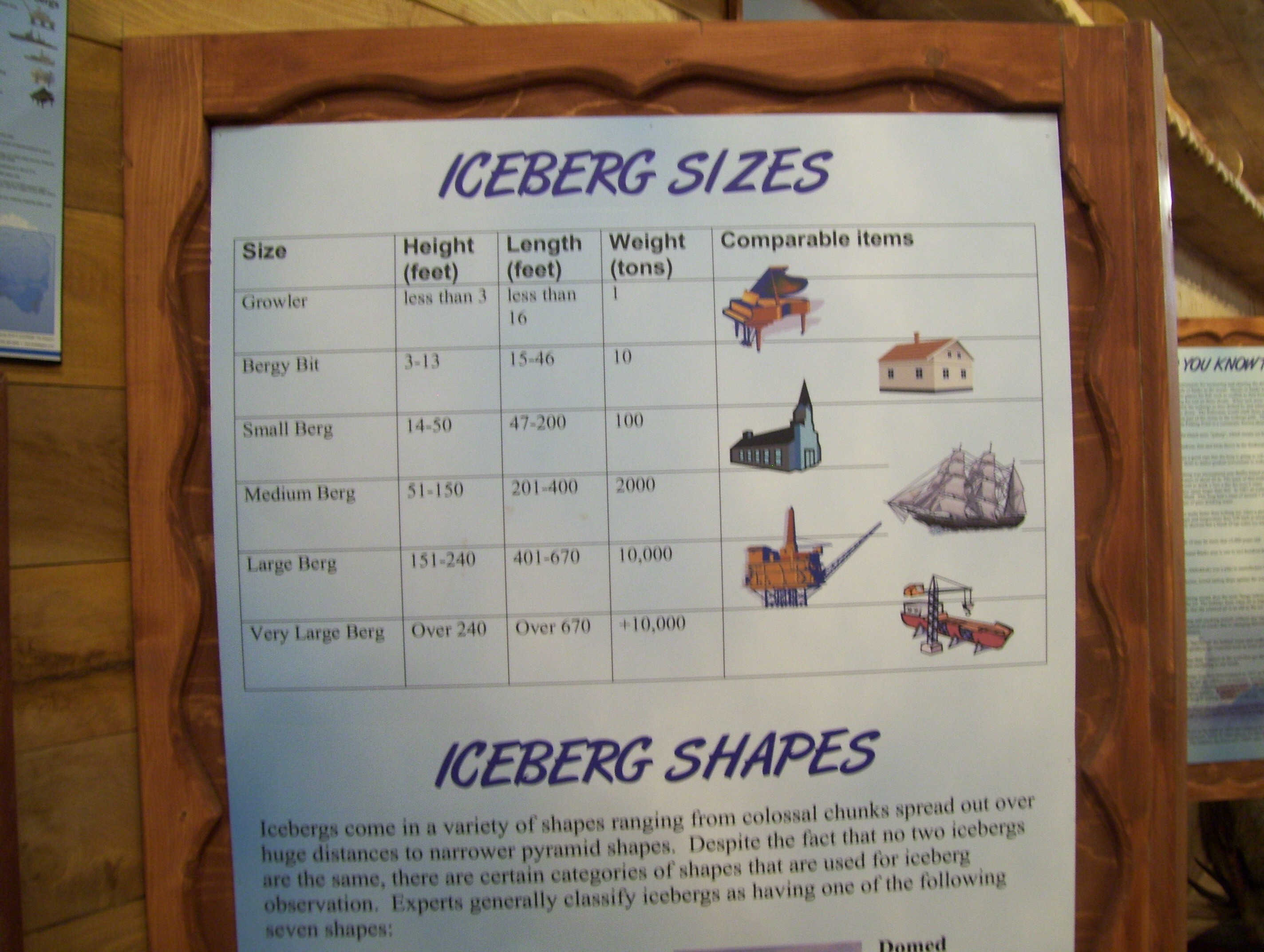
Like snowflakes no two icebergs are identical and the shape can vary drastically but there are general references.
The smallest are referred to as growlers and weigh up to 1 ton. A bergy bit is about the size of a house and can weigh up to 10 tons. A “small” iceberg weighing up to 100 tons, is the size of a large church. Medium refers to icebergs up to 2000 tons while large ones can range up to 10,000 tons. Very large icebergs can be over 240 feet in height, over 670 feet in length and weigh in excess of 10,000 tons.
We didn’t witness anything more than a few growlers and possibly one or two small bergy bits on our trip.
We stayed in St. Anthony for two nights but could have stayed much longer and in a way hated to move on.
On July 14 we drove to Port Aux Choix National Historic Site on the west side of Newfoundland’s Great Northern Peninsula, an area that has been populated for thousands of years. Inhabitants have included many different groups of people. The remains of four ancient cultures have been found there. Archaeologists searched many years for a site like this, which sheds new light on the understanding of native peoples in this part of the world.
After our brief stop we moved on to Gros Morne National Park, where we camped for three nights.
Gros Morne covers 1805 square kilometers and, like Red Bay and Lance Aux Meadows, has been designated a UNESCO World Heritage Site.
There is much to do in the park for people with a wide variety of interests. Hiking is a major activity and can range from simple trails to one that requires participants to be accomplished hikers and prove they have the skill level to tackle the grueling terrain.
This trail is not for the faint of heart and definitely not for anyone lacking in stamina. There are areas of the trail where climbing skills are required, both ascending and descending. It takes several days to complete and you are in a total wilderness. There are no facilities along the trail and no accommodations. Camping gear must be carried.
Access to this trail is via a boat tour of Western Brook Pond where hikers are dropped off at a dock and immediately begin their climb up the first leg of the trail.
The boat tour of Western Brook Pond is a must for any visitor to Gros Morne; however, weather conditions do have an effect on the availability of tours.
The tour takes you into a fjord, which was once part of the ocean but is now well above sea level. The water is deep but contains no fish.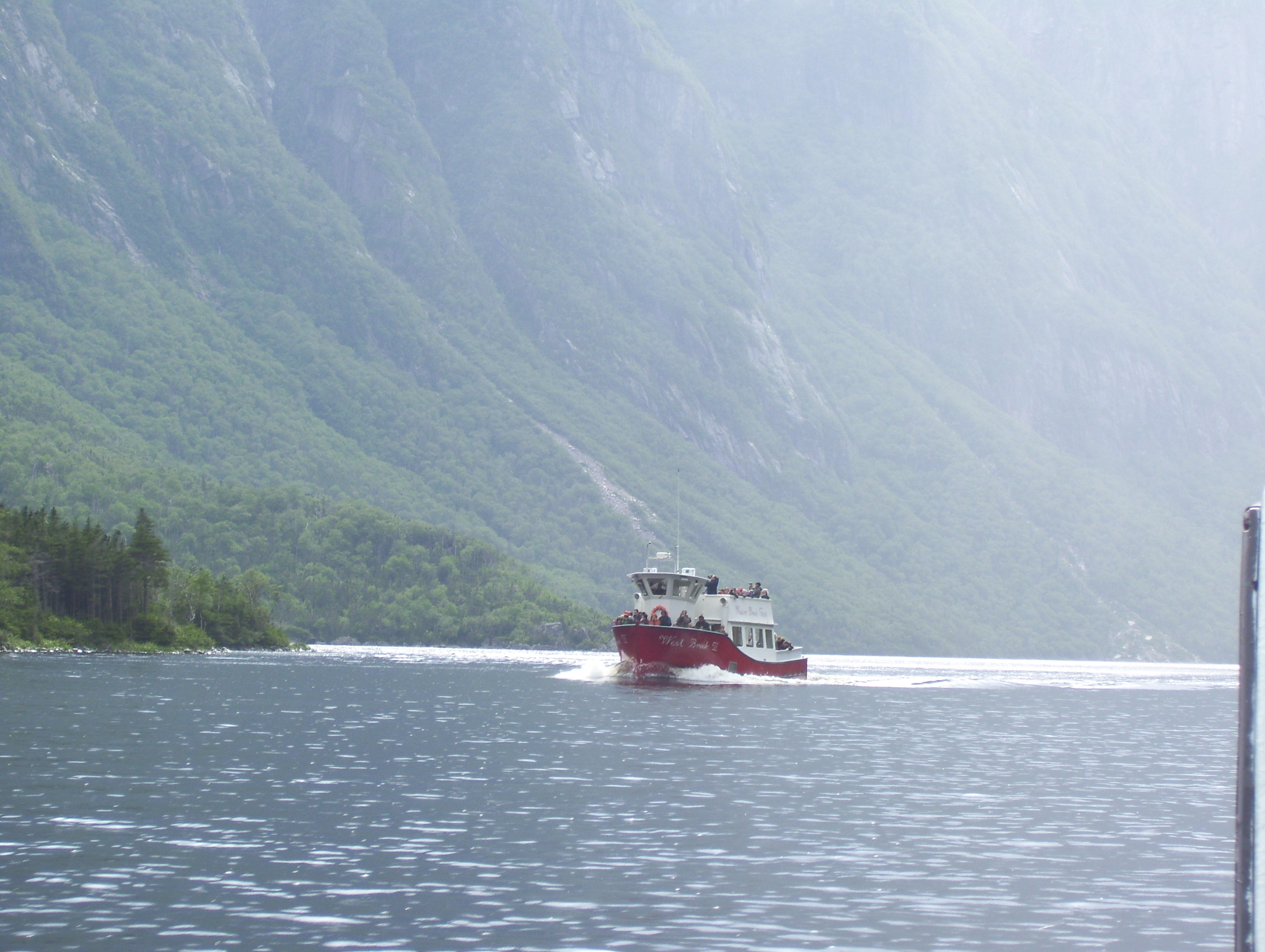
It was stated that if water ceased to enter the lake it would take about six years for the volume of water in the lake to drain at the rate of flow of the small stream that runs out of it to the ocean.
The views are spectacular with shorelines rising as much as a kilometer above the surface, often protruding into the clouds.
 A number of waterfalls cascade down the rocky ledges and are some of the highest in the world, although not enormous in volume. This was definitely another highlight of our trip.
The hike into the dock is fairly lengthy, about 3 km, but is mostly over boardwalk and quite accessible.
The two boats used for the tours had to be transported into the lake, one by helicopter and one overland in the winter, as there is no navigable waterway connected to this lake.
Another area of the park that is interesting is called the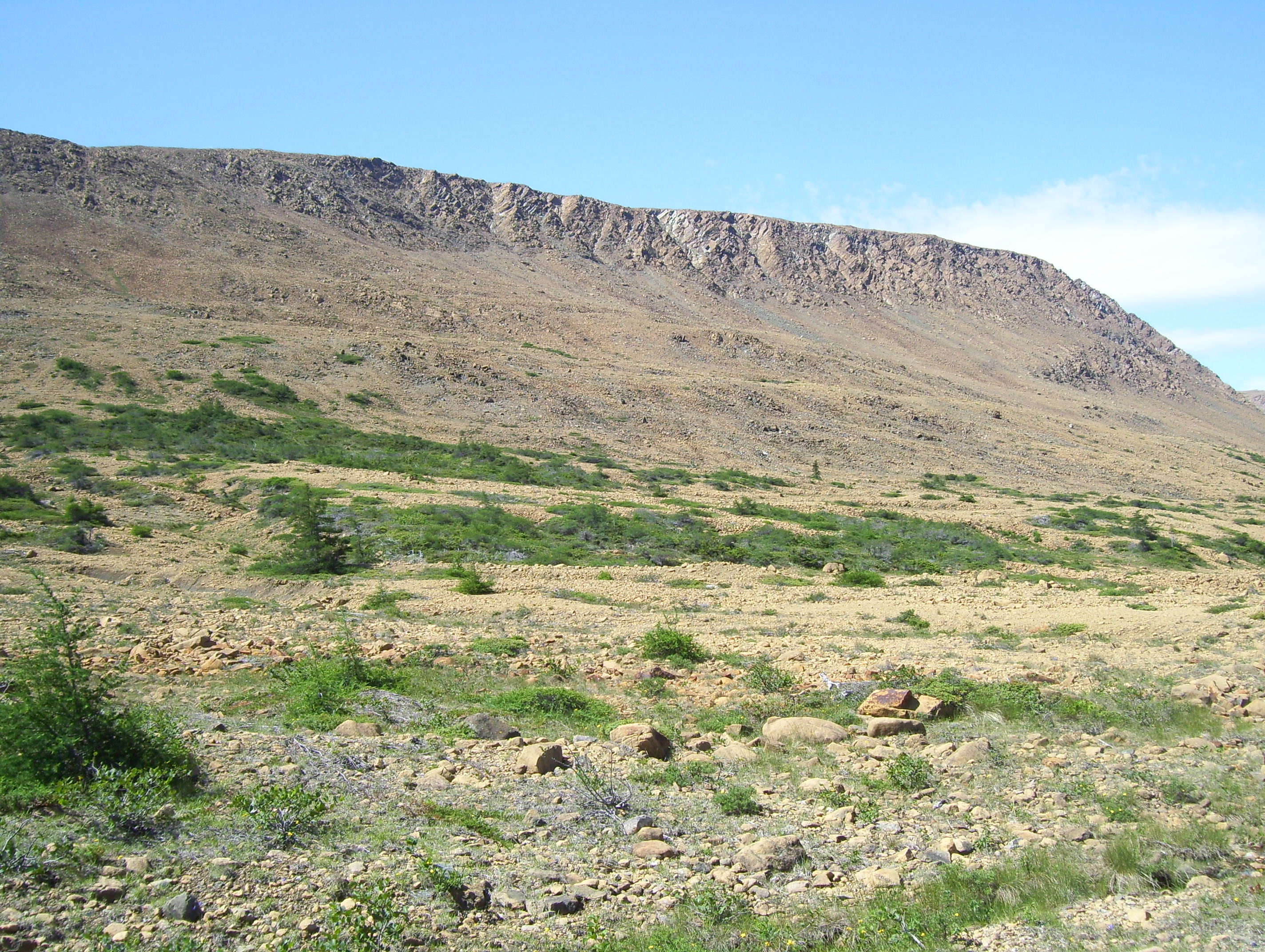 tablelands. Here, over 1.2 billion years ago continents collided and bedrock was exposed from deep in the earth’s mantel. One can walk the trail and see this exposed surface on which there is no vegetation, yet virtually on the other side of the trail trees, grass and shrubs grow normally.
On July 17 we left Gros Morne and took a side trip into Sir Richard Squires Provincial Park, where we watched salmon navigate their way up the falls.
Again, this is a treacherous piece of waterway and a sign drove home the Newfoundland sense of humor.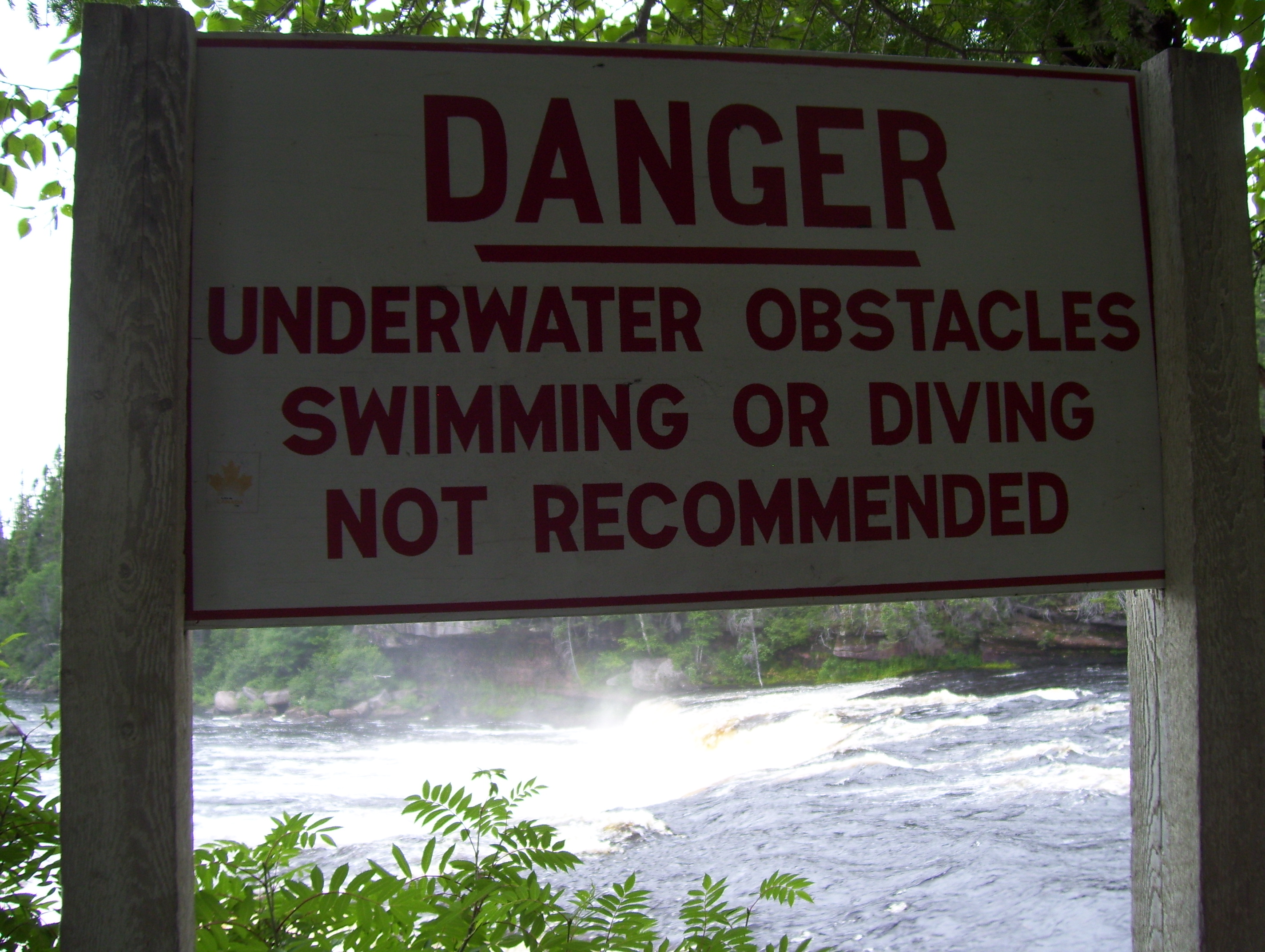
Beside the stairway that runs along the raging rapids below the falls it reads “swimming and diving not recommended.” Anywhere else it would say prohibited.
Anyone with common sense would immediately know it would be idiotic to attempt to swim in such waters.
From here we headed east towards St. Johns and got as far as Notre Dame Provincial Park, between Grand Falls-Windsor and Gander, where we camped for the night.
 On July 18, the end of our second week on the road, we visited Bonavista, a town 4000 and the landing site of John Cabot in 1797.
On display in the harbor is a replica of the Mathew, the ship that Cabot sailed to the new world.
We also paid a visit to the Bonavista lighthouse.
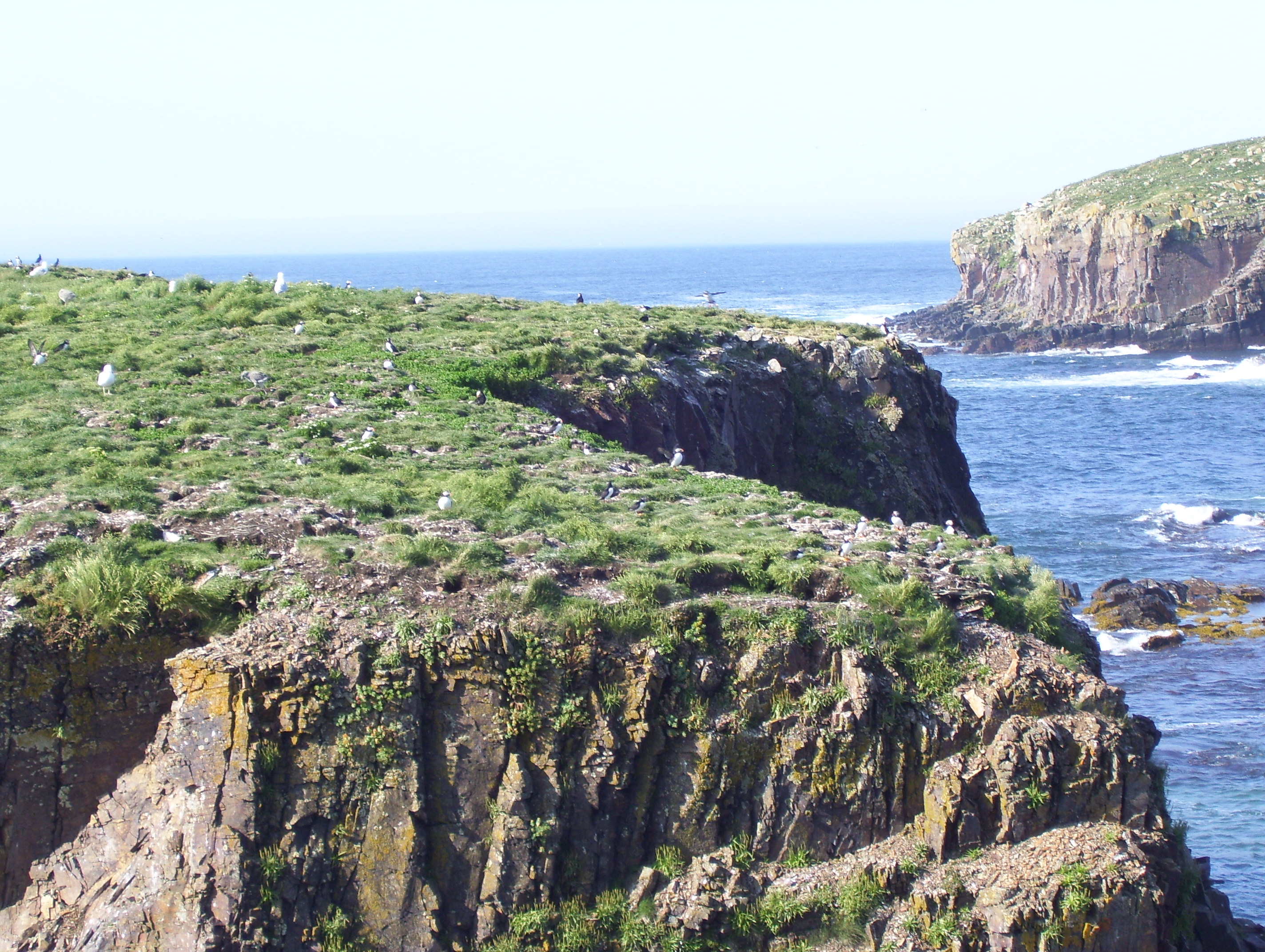
On our way back down the Bonavista Peninsula we drove through Elliston, a town that bills itself as the root cellar capital of the world. Virtually every home has a root cellar in their back yard.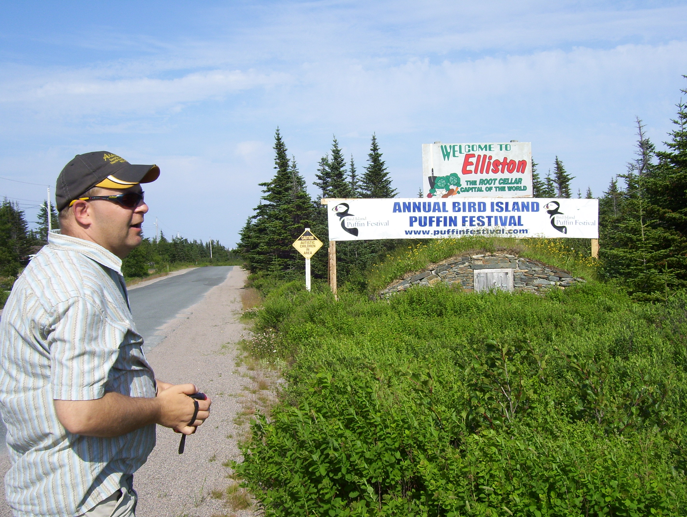
We also made a brief stop at the annual puffin festival. The area is the summer home to hundreds of nesting puffins and one of the best places to view these interesting little sea birds.
 From there we made our way to Butter Pot Provincial Park, not far from St. John’s, where we camped for four nights and made several side trips around the Avalon Peninsula.
The first full day in the area we went to St. John’s, drove around the downtown and harbor area, familiarized ourselves as best we could with the city, then made a stop on Signal Hill.
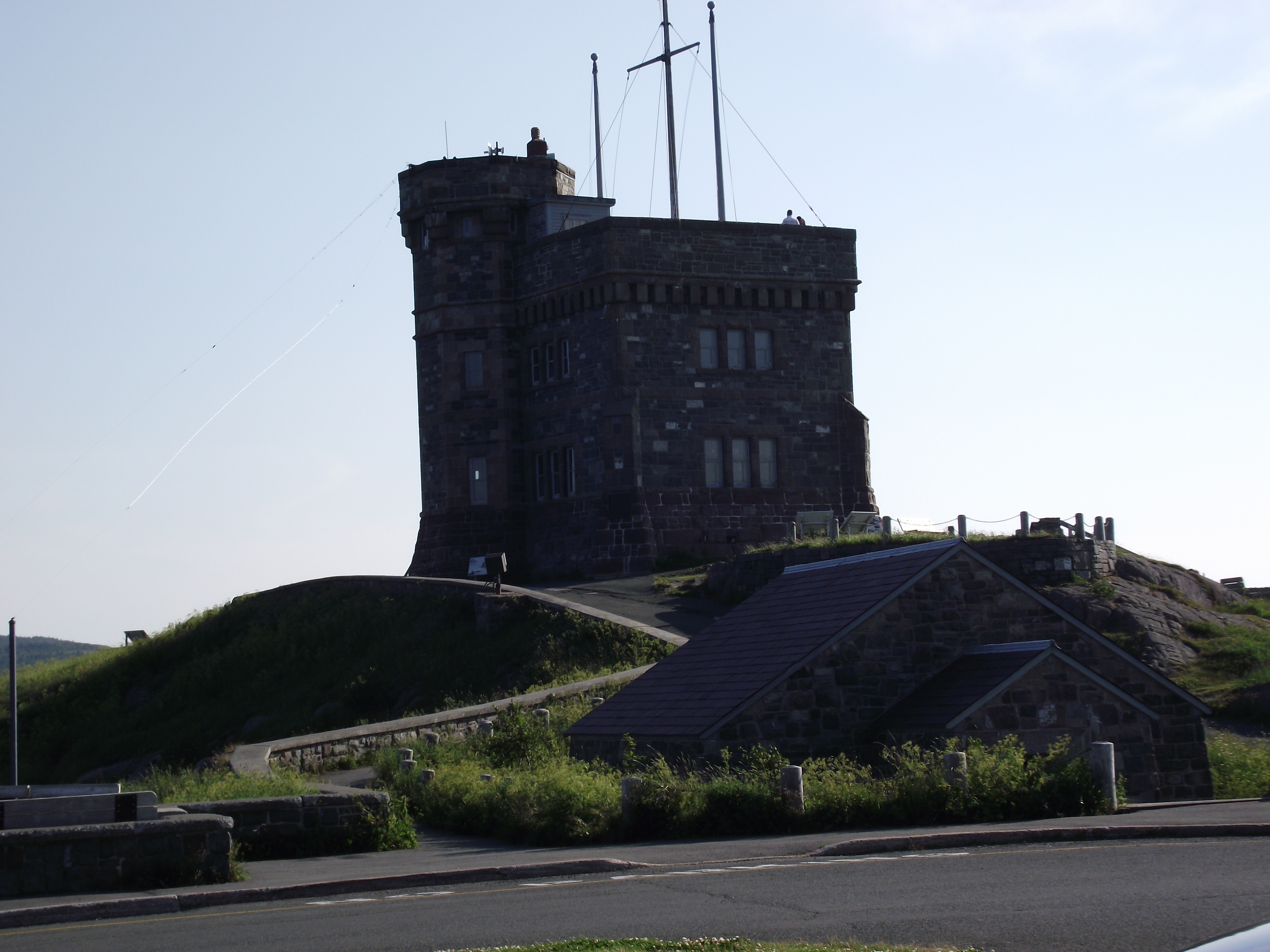 This is one of the many National Historic sites in the province and it got its name because many years before the advent of ship-to-shore radio signalmen perched on the hill would survey the ocean for approaching ships and use flags to identify those ships to the inhabitants of the harbor-front below.
It is also the site where Marconi received the first-ever transatlantic wireless signal in 1901.
This was a perfect day, very sunny and exceptionally warm for Newfoundland. The temperature was 30c. However, there was a brisk breeze, which made it feel quite comfortable.
A couple of days earlier an announcer on the radio had commented on the heat wave they were experiencing, saying that the temperature was 25 with a humidex of 28 and hoping the heat wave would soon be over.
Back in Ontario the temperatures had been consistently in the mid to upper 30’s with the humidity making it feel like more than 40.
The view from Signal Hill was spectacular and we saw several whales surfacing in the ocean beyond the outlet of the harbor.
Signal Hill offers an excellent view of the city and the ocean beyond the harbor entrance. It is also know for its propensity to high winds.
By the time we explored this area it was too late in the day to head for Cape Spear so we went for a nice dinner then headed back to our campsite.
On July 20 we drove to Bay Bulls and checked out some of the whale watching tours then drove what is referred to as the Irish Loop, stopping at La Manche, the site of a town that was wiped out by a major winter storm in January 1966. Fortunately there was no loss of life attributed to the storm.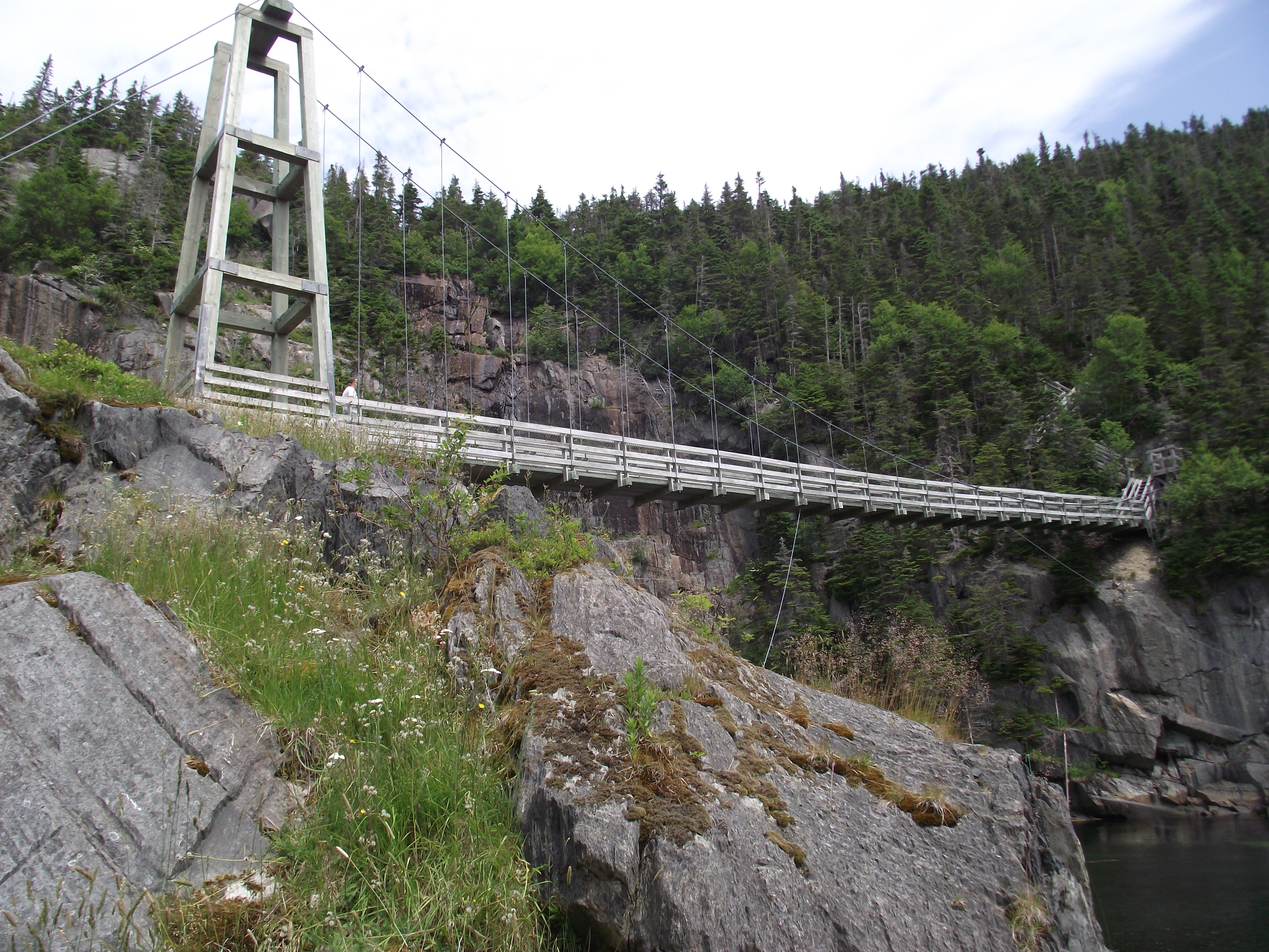
A number of the foundations were still visible and the original suspension bridge, which was also destroyed in the storm, had been replaced in 1999 with a new suspension bridge. The area is now a provincial park.
From the parking lot it is about a 2-3 km. hike to the town site. Part of the East Coast Trail winds through the former town site.
From here we drove to Ferryland, which has a current population of just over 500 but is one of the most historic communities in all of North America.
Founded in 1621 by Lord Baltimore it is said to be the birthplace of religious tolerance and freedom in the new world.
We drove up the point as far as we could, then hiked the 1.5-2 km. to the lighthouse.
Whales were visible off shore but too far out for any significant viewing. The temperature on the point was several degrees cooler than it had been further down the trail.
Fog began rolling in and remained the rest of the drive. We had dinner in a seaside restaurant along the way, but given the fairly heavy fog the ocean view was severely obscured.
The next day it started raining early in the morning, so we drove to St. John’s looking for a restaurant at which to have breakfast.
We could not find a regular restaurant that was open for breakfast and ended up in a deli. The menu left much to be desired and they said they couldn’t do scrambled eggs, only fried eggs, obviously not fresh but precooked.
This was a day for inside activities so we went to the Johnston Geo Centre located on the way up to Signal Hill.
This is an amazing facility built into the bedrock. Displays of a geological nature
abound and there are also displays relating to the Titanic and to the off shore oil industry which has brought prosperity to the area.
We spent most of the day in this fascinating attraction and when we emerged at about 5:30 p.m. the rain had stopped and the sun was out, so we headed for Cape Spear, the furthest point east in North America.
Again we saw whales in the ocean out from the entrance to the harbour. These were closer than the ones we had seen the previous day but still at quite a distance.
July 22 was a beautiful day warm but not too hot. We drove to Mobile and took a whale watching tour on a small boat with only about a dozen people. This was much better than the larger boats because the larger crowds make it more difficult to move about the boat and actually get a good look at these enormous creatures.
We saw lots of whales frolicking in the ocean very close to the boat. The whales put on a show that is entertaining to sightseers.
The captain explained that they are actually waiving their fins and slapping the water with their tails to warn intruders (us) that this is their territory and food source.
After this exciting adventure we drove the North Avalon Peninsula along Conception Bay and through Topsail, Pouch Cove and back to St. John’s via Torbay.
It was interesting to note the extent of development taking place in the area, obviously due in large part to the development of the off shore oil industry.
Back in St. John’s we paid a visit to the world famous George Street, home to numerous pubs, bars and restaurants in a short two block area. It is the center of the entertainment district in this city that is colorful in more ways than one.
After leaving George Street we played a round of mini golf before heading back to the campsite for the night.
On July 23, my 44th wedding anniversary, we packed up and left Butter Pot Park and headed west on the homeward stretch of our trip.
We took a side trip to Bay Roberts, Carbonear and Heart’s content. With names like Heart’s Content, Heart’s Desire, Dildo and many others, one has to appreciate the sense of humor and simple logic of the early settlers of the island.
Yet another side trip took us down the Burin Peninsula to Marystown and Grand Banks. We contemplated going to St. Pierre and Miquelon but decided against it due in large part to the cost and the lack of activities we felt would be of interest.
The next day was the opening of cod fishing season and we tried to arrange for a charter boat just to try our hand at the sport. Although it was difficult to find someone to take us out for the brief experience we were seeking, we did find a reluctant captain who was willing to accommodate us. However, the weather the next morning was not very good and the winds made the water very choppy, so we decided against it
We had stayed overnight at a motel in Marystown and headed back up the peninsula in the morning, stopping along the way to do a bit of trout fishing, catching half a dozen but releasing all but two.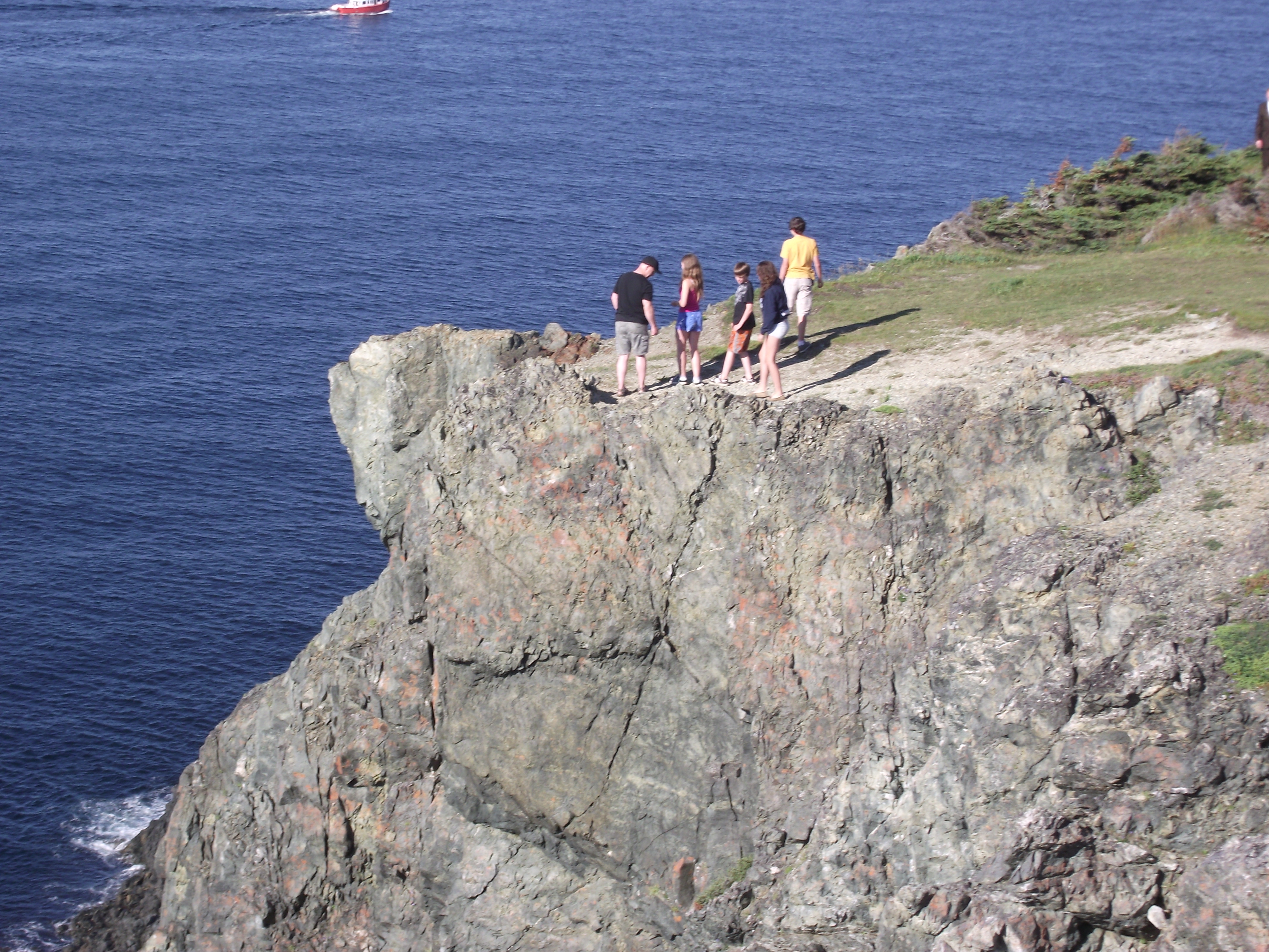
We stopped to camp again at Notre Dame Provincial Park. Since we arrived in the late afternoon we decided to take yet another side trip (everything in Newfoundland is a side trip) to Twillingate and Crow Head. Although all the shorelines of Newfoundland are rugged, the cliffs at Crow Head were spectacular.
On the way back to camp we stopped at a roadside food stand near Lewisporte where we had crab and lobster sandwiches. Even though seafood is not my favorite fare these sandwiches were delicious.
The next morning we headed west again on the Trans Canada Highway, which only opened in 1969. Prior to that there was no easily accessible route between eastern and western communities.
With a short visit to Rattling Brook Falls we arrived in Corner Brook in mid afternoon. A stop at the tourist information booth yielded little in the way of information about local attractions.
Most of the employees at these establishments are teenagers working summer jobs and like most teenagers, think there is nothing to do in their hometown.
However, just down the highway a sign for an adventure operator prompted us to exit.
It turned out to be an amazing place, offering everything from rock climbing to deep-sea fishing, white water rafting and even packages to fly you into a mountain lake for some spectacular fishing.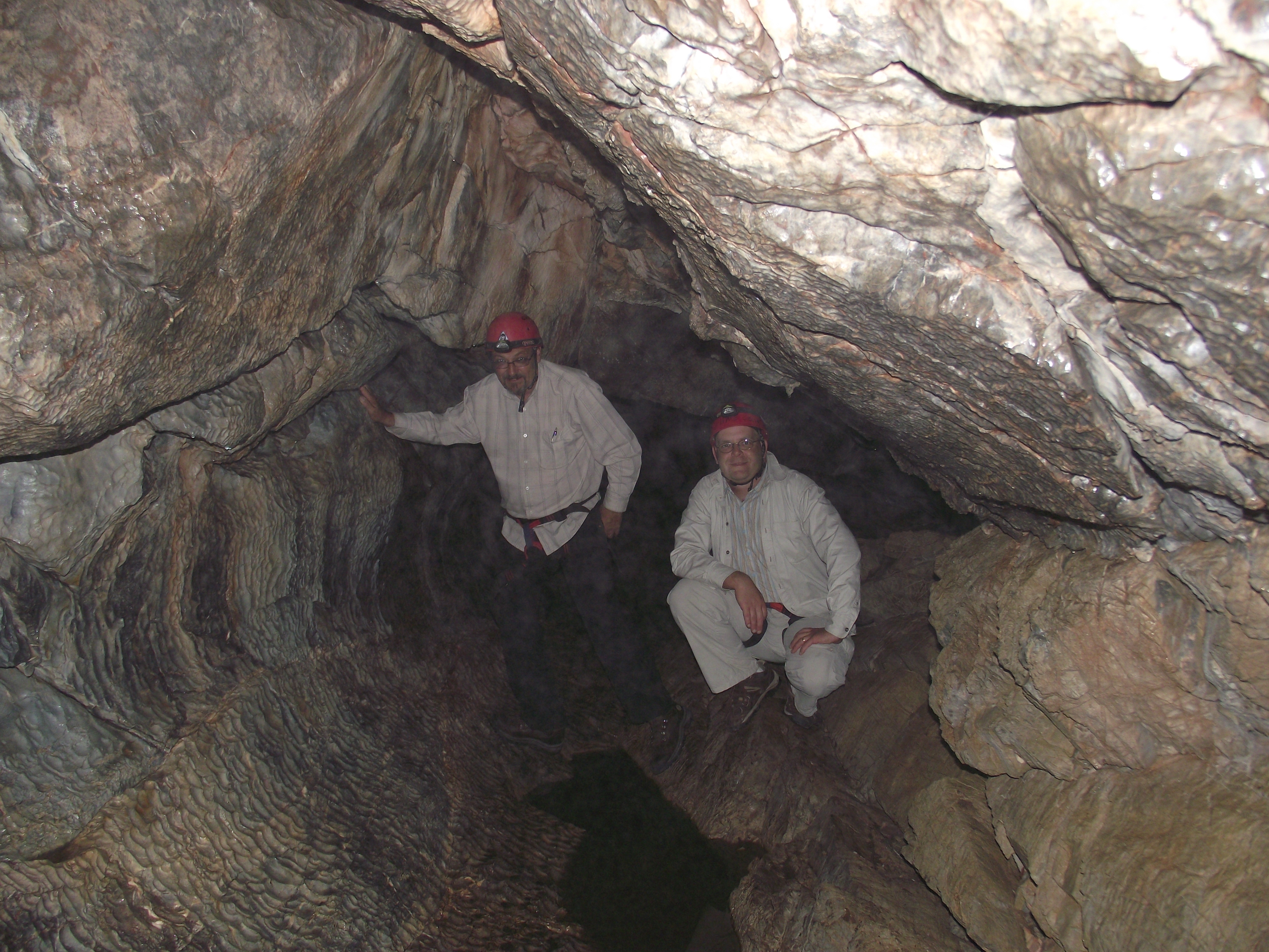
There was something for every level of interest. Since my son said his wife would never go into a cave we decided on a guided cave exploration.
The entrance to the cave was quite accessible but further in we had to repel down a steep ledge and at one point had to squeeze through a fairly narrow, sloping passageway to a large opening and an underground stream. The area was pitch black and without headlamps one would not be able to find their way. This was about a 3-hour adventure.
We were now on our way to Port Aux Basque, and were running a day ahead of schedule. We called the ferry and were able to move our sailing time up to the next day.
That night we stayed at a small roadside motel on the Trans-Canada near the exit to Stephenville and had an interesting conversation with the proprietor.
It was a little over an hour from there to Port Aux Basque so we didn’t need to get on the road too early the next morning. We arrived at the ferry terminal about 10:30. Our ferry was scheduled to sail at 1:30 so we had a bit of time to explore the immediate area.
There were delays in the sailing time and we didn’t get underway until 3 p.m., arriving in North Sydney at 7 p.m. (actually 6:30 p.m. due to the time difference between Newfoundland and the mainland).
We dove to Antiginish Nova Scotia, where we stayed for the night. The next day, the 23rd of our trip we drove all the way from Antiginish to Cornwall, Ontario.
Seems once you are on the final leg of a trip there is a desire to get home, especially when you are back in an area you have visited previously.
We did make one stop our final day on the road to visit briefly with my cousin near Trenton and arrived back in Peterborough at about 4:30 p.m. on July 24.
What an awesome trip filled with excitement and many memorable experiences. Given the opportunity I would do it all over gain in a heartbeat.